
DATA MONITORING SYSTEM
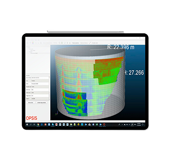
Laser Scanning Data Software Opsis
Encardio Moniterra Group unveils a new era of sustainable structural deformation monitoring.
With over 50 years of experience assimilated in one unique application for deformation monitoring using laser scanning data, OPSIS is the brilliant software that is going to redefine monitoring philosophy – a true game changer!

ADVANTAGES
OPSIS is a data analysis software that processes 3D data collected by a laser scanner. It optimizes the huge data from laser scanner and provides an analysis directly from the 3D data for accurate and fast monitoring of deformations.
With OPSIS one can have complete deformation overview maps, time-displacement graphs and animations depicting deformations occurring with time, in a snap!
- Reduces cost by saving time and resources, while lowering risks and without compromising safety.
- Leaves no spot unattended! Simply zoom in at the potentially problematic area and evaluate at a glance!
- Full coverage of the structure’s surface – monitor in between other installed sensors
- Interpret by correlating data with other parameters – wind speed, water table, total pressure, temperature, etc.
- Automatic elimination of points away from the template’s surface
- Measures without jeopardizing the safety of personnel to install and maintain prisms at risky locations – at high rise structures, dams, tunnels, landslides, slopes, caves, monuments, etc.
- Due to its fast speed, scanning ensures evenly distributed environmental effects – wind speed, solar radiation, temperature, refraction, etc. over the monitoring duration.
- Measures contactless. Eliminate possibilities of mishaps such as traffic and construction site accidents
- Evaluate at a glance. Every second counts in monitoring!